Due to the location of the Seaholm Residences, a lot of people ask the question of whether or not Town Lake, or Lady Bird Lake, has the potential to flood the Seaholm Residences.
 You may have seen the infamous photo of the Stevie Ray Vaughan submerged in water. Luckily, that amount of flooding is rare. The photo here was taken in 2013. Contrary to popular belief, flooding at Town Lake doesn’t occur due to heavy rainfall.
Because of the Lower Colorado River dam system, our urban rivers are extremely reliable in terms of flooding. From Buchanan Dam down to Longhorn Dam, each river system is designed to prevent flooding in and around Austin. In the late 1800s and early 1900s there were several record floods that caused damage and even cost lives. According to reports, the high water mark for flooding in Austin is currently 43’, a record that was set in 1869.
Since then, Austin has rebuilt it’s dam infrastructure to accommodate pretty much any amount of rainfall, however, there are still instances where certain areas will flood as the LCRA opens floodgates to relieve stress on the dams.
Notably, in October of 2018, Austin received a huge amount of rain in a short time forcing the LCRA to start opening floodgates on Tom Miller Dam, which is the dam that forms Lake Travis just above Lake Austin. In this scenario, the controlled release of water flooded all of Lake Austin, including Barton Springs.
In cases like this, waters near downtown rise, resulting in flooding of popular places like Lady Bird Lake Hike and Bike Trail, Barton Springs Pool, and even the Stevie Ray Vaughan statue.
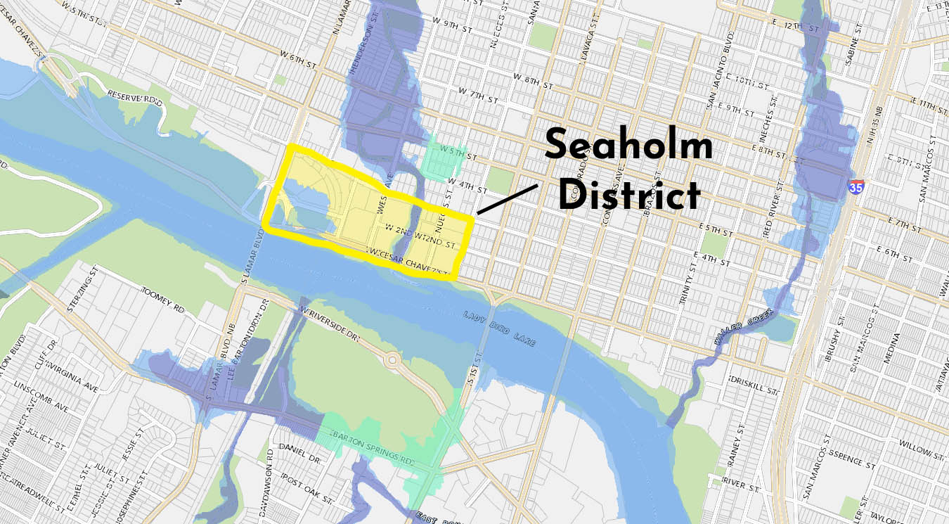
That level of flooding is expected. In fact, a good portion of Barton Springs and other parts of downtown near the Colorado River are located in a flood plain. Here’s a map:
So you might be wondering if there could ever be so much flooding that Town Lake could have the potential to flood Seaholm.
Austin’s city plan is designed to accommodate for flooding. Due to our notorious past of flooding and our city being located right on the Colorado River, there are strict building restrictions on where one can build, what they can build, and how it impacts the surrounding environment.
You can see in the map above that there are sections of the Seaholm District that fall within the LCRA floodplain. To the west of the Seaholm Residences building there’s a section that has the potential to flood from Town Lake. To the east, Shoal Creek has the potential to flood down into Town Lake from a larger flooding area just north of the Seaholm District.
Based on the flood map data above, it doesn’t appear that there’s any chance of flooding for Seaholm.
But if that wasn’t enough data, the City of Austin maintains high restrictions on building in or around a floodplain, so they wouldn’t have given approval on the project in the first place if there was even a chance of flood damage.
Rest easy, Seaholm Resident! There is no scenario where the Seaholm condo tower could possibly flood from heavy rain waters.